Lake Merced’s History
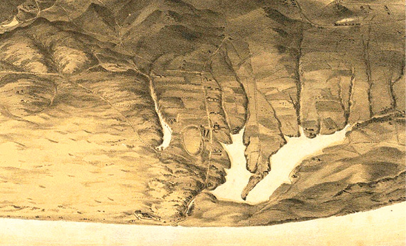
An artist’s birds eye view of Lake Merced in 1868 shows the lake draining into the ocean. Image: George H. Goddard, Library of Congress
Lake Merced was first noticed by the Spanish in 1775 by Captain Don Bruno de Hecta who named the lake Laguna de Nuestra Señora de la Merced. (1) Originally, Lake Merced was intended to provide a water supply to the growing city of San Francisco. The Spring Valley Water Comany (SVWC) which was formed by a collection of powerful capitalists purchased Lake Merced for $150,000 in 1868 and developed a monopoly on San Francisco’s water. For the next 30 years, the City of San Francisco sued SCVW over the cost of water, leading San Francisco to look elsewhere for a reliable water source. When water was secured from Yosemite Valley and the Hetch-Hetchy Dam was built, the aspiration of San Francisco having its own water source was realized. Then, Lake Merced and the surrounding land became less valuable and portions of the property were sold off to numerous golf courses, the San Francisco Zoo, Stern Grove, San Francisco State University and what later became known as Fort Funston.
Eventually, water would flow into the Pacific Ocean from Lake Merced as winter waters became too much for the lake to hold. There is an “eye witness” account on November 22,1852 of a loud crack. Then, a fissure appeared 1/2 mile wide and 300 yards long which allowed the water of Lake Merced to flow into the Pacific Ocean. The next day the water was noted to have dropped 30 feet. A subsequent map of the lake showed the fissure remained 29 years later. (2)
In the 1950’s the state Public Utility Commission transferred the surface water over to the San Francisco Parks and Recreation Department if several conditions were met. Unfortunately, due to development around the lake and over pumping of the Westside Aquifer by numerous golf courses, cemeteries and municipalities, the water level of Lake Merced dropped. When this occurred, the fish stocking of the lake which exceeded 250,000 at one time, diminished. (2)
THE WATERSHED:
Looking at the above artist’s map of 1868, we can see the watershed that provided Lake Merced its water was extensive. Water flowed from the Olympic Club west. To the north, water would flow from a portion of the Richmond district. From the east, water would flow from TPC Harding Park, Parkmerced, the San Francisco Golf Club, most of the Ocean View district and from the “Top of the Hill Daly City”. Most of this water would flow into a seasonal or permanent stream where Brotherhood Way is today. However, the most notable watershed comes from the south or from the Westlake district. From the map above, we can see that all or part of the Westlake Shopping Center could be underwater. Lastly, water flows into Lake Merced also from an underground spring. (1) Some believe Lake Merced could be a surface feature of the Westside Basin Aquifer underneath.
LIQUIFACTION DANGERS:
One of the streams that fed Lake Merced traveled down where Brotherhood Way is today. Therefore, after millennia of water flowing down this historic stream, the soils here are organic in nature and subject to liquefaction. Brotherhood Way also is where an earthquake fault can be found. A study of the 1906 Earthquake explained just how vulnerable to earthquakes the Lake Merced region is. During the 1906 earthquake, a bridge was damaged beside Lake Merced. “The bridge was broken in two places … At one break the west piece was shoved 12 or 14 feet past the other section. The west end of the intermediate piece failed to join the section at the west bank by 6 or 7 feet. The west section that remained with the bank was 4 to 6 feet lower vertically than the intermediate piece.” (3) This drastic movement of the land in this location makes the new development in Parkmerced especially vulnerable, not to mention the existing Parkmerced towers present there today.
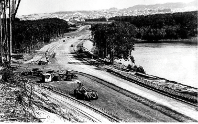
Photo: SFDPW, courtesy C.R. collection Skyline Blvd. north at Great Highway. Lake Merced at the right, March 15,1937.
CONSEQUENCE OF HISTORY IGNORED:
The completion of the road around Lake Merced in 1937 ends the opportunity for water to ever exit into the Pacific Ocean. Now, we are faced with erosion, beside the Great Highway, where water once flowed into the Pacicfic Ocean from Lake Merced. Today, the Oceanside Water Pollution Control Plant is now in danger because of the combination of ocean armoring and fragile soils where once a stream flowed into the ocean. (4) A modicum of research, by a curious engineer, could have avoided this unfortunate location for this sewer plant. San Francisco needs to do better in its planning of communities, like the new Parkmerced and in locating critical infrastructure sites.
SPORTS FISHING:
With the increased control of nitrogen laden runoff water from golf courses, the improvement of the lake for sports fishing increases. However, any set back in the control of nitrogen entering the lake, can cause mass die offs of recreational trout. When this happens, the recreational trout fishing program needs to often restock the lake again. The nitrogen laden water would generate algae blooms contaminating the water by eliminating oxygen in the lake. This nitrogen laden water would be so toxic that even Stickleback, which are considered extremely hardy, would perish in large numbers.
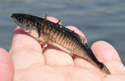 The Threespine Stickleback gained access to Lake Merced when there was access to the lake by the Pacific Ocean. With this access, several other species of fish, tolerant of brackish water, gained access to the lake as well. Some of these fish are still found in Lake Merced today. Indigenous fish species, would often outcompete with the recreational trout. Therefore, these “rough fish” were eliminated or greatly reduced, by poisoning the lake with rotenone, a poison that effects wildlife but not plant life. Despite the fact numerous times the lake was poisoned, the Threespine Stickleback and other brackish fish are still present. What is most amazing, is that the original species of fish, the Sacramento Perch and the Sacramento Blackfish, present when the Spanish originally discovered the lake, are still present today. (5)
LAKE MERCED IMPROVING:
Lake Merced is believed to be improving since the year 1990. One of the most important reasons is because the water in the lake is rising. When the Blended Water Program starts in earnest, using 15% of our ground water to dilute with our pristine Hatch Hetchy water, this may cause the lake to lower. The Pacific Rod and Gun Club (PRGC) is gone and with it the noise pollution of shotguns. The clean up of the gun club cost $22 million. However, missing in that cleanup was the lead buckshot that landed into Lake Merced. A justification that ducks no longer land on the water was given, however, when I visited the lake, there were a dozen ducks on the water. As years pass and young ducks, unfamiliar with the firing range, are likely to return and dive for food in the sediment below. Replacing the PRGC is a 10 acre cleanup/ remediation project which included the removal of 58,600 cubic yards of contaminated soil. After the soil was removed, it was replaced with clean soil and planted with 2” to 3” high grass. Today, all the buildings remain during the time the Pacific Rod and Gun Club. If the PRGC is to have a new use, it would seem these buildings should be removed. The remediation of PRGC began in May 2015 and ended in April 2016. (6) Now, the San Francisco Police Department Pistol Range, north of the PRGC, uses iron or bismuth munitions instead of lead. This is a big improvement.
FOOTNOTES:
(1) https://en.wikipedia.org/wiki/Lake_Merced
(2) http://www.outsidelands.org/lake-merced.php
(3) The California Earthquake of April 18, 1906: Report of the State Earthquake … – California. State Earthquake Investigation Commission, Andrew Cowper Lawson, Harry Fielding Reid.
(4) http://explorebeaches.msi.ucsb.edu/beach-health/coastal-armoring
(5) http://www.lmtf.org/FoLM/Data/SFSUReports/fish.htm
(6) http://sfwater.org/index.aspx?page=863
Glenn Rogers, RLA is a Landscape Architect working on the westside of San Francisco.

Hi, Great article Glenn. I have a couple of comments, about the seismic issues around Lake Merced. In the Lawson study, he identifies the West shore of the lake as having shown the greatest liquefaction issues. The railroad trestle that was destroyed went over the shallow strip (now raised and paved) between the North and South lake. During the 1957 quake, large roadbed damage, due to liquefaction occurred there and also along the West shore of the South Lake along John Muir Blvd. The Brotherhood Way (Stanley Drive then) developments were not there in 1957, but no damage was seen there following the Loma Prieta earthquake. Liquefaction needs a clay lens (organic or otherwise), high water table, and a good shake. All surface water entering Lake Merced from creeks, storm drains or sewers had been diverted around the lake and out to the ocean since about 1890, and the outflow from the lake had been via a brick lined canal from 1870’s on. A weir was placed at the start of the outflow creek to control the level of the lake. I don’t understand how this water control is now contributing to the ocean shore erosion near the water treatment plant. Current shore hardening (boulders) is in response to the erosion, not the cause. Maybe a modicum of research, by a curious engineer could yield better design or placement for a water treatment plant, but I don’t know what site would be desirable or practical, given the city that has grown to fill it’s boundaries. The current treatment plant deals with sewage and storm drain water – which gets mixed during large storm events (due to the design of much of San Francisco Sewage/Storm Water system). Ocean Beach used to be closed, periodically following storms, due to the release of raw sewage and high bacterial count at the beach – this doesn’t happen now. The design for the new ParkMerced (if it ever gets built) has many eco-sound designs, but also a dozen high rise towers (slightly shorter than existing towers) to replace the one and two story housing units. Thanks again for writing this very concise article.